There are three "kinds" of curvature we can readily observe to know the Earth is a very large spheroid.
First of all you need to understand that your horizon is NOT the same as looking at "the whole Earth", you can see only a very tiny portion of the Earth until you get a very great distance away (several Earth Radii). Your view is limited to where your line of sight hits the Earth. The closer you get the less you can see of the whole. I tried to demonstrate this effect of perspective here:
For example from 35,000 feet your view is still microscopic.
Even at 400km where the International Space Station is you still have a very limited view. This is why Flat Earthers say the whole Earth won't fit in that view -- IT WON'T AND SHOULDN'T.
So...
Curvature #1 is to observe that your horizon is (roughly) equally distant in all directions -- if it CURVES around you it simply CANNOT also be flat in every direction you look. That is just completely absurd. Even on a Flat Earth your horizon would be limited by the atmosphere and would STILL BE A CIRCLE. It only LOOKS "flat" because you are viewing that very large circle almost completely on edge. How "round" does a penny look when view on edge?
Furthermore, it is trivial to observe that as you gain elevation the distance to your horizon grows. You see much further up on a mountain than you do down on the ground, even over water. So Flat Earth needs to explain why, when we look through MORE atmosphere we see further and why a 3 mile horizon is very very sharp and a 50 mile distant horizon is extremely fuzzy -- if it's the atmosphere blocking your view it should be fuzzy at 3 miles also. And why can we see the much more distant stars right down to the horizon but can't see a 1000 foot tall building that is between them?
Curvature #2 is the horizon apparent Sagitta curvature. This is the apparent 'hump' of the horizon due to viewing a circle at a very oblique angle. This is probably what most people think of when they think of seeing the "curvature of Earth" -- but you CANNOT, you ALWAYS see a horizon. At several radii away from a spheroid you start to see close enough to half that it looks like you are seeing a normal "ball". For the Earth that would be several thousands of miles away, that's why only very distant satellites can take an image of the Earth and it looks like a globe (see Himawari-8, DSCOVR/EPIC, and GOES-16 imagery).
To see this kind of curvature with your naked-eye you need to be fairly high up and have a wide field of view and a very clear day. The higher the resolution and the wider the field of view and the more careful you are about your observation the lower you can detect or measure this kind of curvature. If you had a very clear day over very calm oceans and you put a very wide straight edge along the horizon you could measure a few pixels as low as a few hundreds of feat.
Curvature #3 is to measure the curvature going away from us by observing that objects appear to shrink exponentially faster the further away they are. The further you can see the more obvious the effect - distant mountains expose this extremely clearly.
There are other ways to measure the curvature but I don't know of any reasonable way to make such observations to test anything because the effects are too small.
Unreasonable Curvature #4 TILT -- Every 69.1 miles objects would be leaning out from you by about *ONE* degree.
But do you have ANY idea how little 1° lean is and it's leaning away from you but at the same time it's now 3000 feet BELOW you, that means your perspective shifts to a very elevated position and you have a perspective shift because of the distance and perspective makes things 69.1 miles away EXTREMELY small. I'm open to ideas but I have no way to test it or try to observe it directly.
This shows a 1° lean - which one is leaning back 1°?s
So let's look at some curvature!
Concorde taken by Adrian Meredith in an RAF Tornado over the Irish Sea - April 1985. Not a "fisheye" lens or the airplane would be distorted/bent also. This is horizon sagitta curvature.
A Flat Earth favorite, they often send it to me! Again, shows horizon sagitta curvature.
here is a neat trick - resize the image horizontally to help the curvature stand out:
But watch out, you'll often find Flat Earthers cheating!
This original of the Pontchartrain Causeway shows a clear curve:
But that's really too much curve for that altitude, possibly a small amount of distortion:
But that doesn't stop Flat Earthers from editing the original photo and trying to use it:
This an image of the clearly sunken CN Tower over the Lake. Taking into account the observer elevation and maybe a touch of refraction this is a perfect example of curvature over the horizon.
another image of distant Toronto and the CN Tower.
And one final CN Tower image which really shows the rotation of the CN Tower SKYPOD view due to us being significantly higher up.
This series is from one of the earliest high altitude images ever taken - on a V2 rocket from 1948. The individual frames are very narrow field of view and so they LOOK flat, but measure slightly curved and when you put them all side-by-side the curvature is fairly obvious.
This is a professional surveyor marking out LEVEL using a theodolite from Apple Pie Hill. We can see that the ground falls clearly below the level mark. Accuracy here is a few arc seconds.
This series is the Incredible Shrinking Mountain Rainer taken from two positions, one near Seattle and the further from Canada where we can only just see the very tip of Rainer.
Here we observe the horizon dropping well below eye-level using the Theodolite app on the iPhone. Accuracy here is roughly 2/10ths of a degree. We see the angle to horizon varies with altitude and the last image is meant to show that it finds LEVEL regardless of the orientation of the phone.
This one is Rainer but taken from Brunswick Mountain
This is one of my favorite things Flat Earthers will throw at me. This is from AirPano
What they ignore is first of all, that is a 360 degree image so the horizon that is a circle has been unrolled. Here is the very next FRAME which is the 360 degree view looking straight down. Guess what, your horizon is a giant circle so it curves around you. Flat Earthers WRONGLY expect to see an "Earth" with the so-called "Limbs Of The Earth" curving down before you. That's just WRONG - that's not what you SHOULD see on a sphere.
X-15 footage, fortunately I was able to find a good schematic of the plane and get a good estimate for the Field Of View from that:
This was a fun one. They claimed this was Denali from Hilltop Ski resort /scratched record sound/, nope -- they even had the WRONG mountain. They NEVER check memes. I suspect someone faked this meme and Flat Earthers just mindlessly parrot them.
I love using Flat Earth's own memes against them, like this Fort Myers to Naples image -- it's a good image because the beach is running further from us and we can clearly see the beach disappears and the building bottoms start to disappear. I also get to catch them lying because that's not 42.7 miles they are 11.7 miles away which puts the hidden height RIGHT where we expect on a curved earth.
My best High Altitude Balloon image with a FULL and deep analysis. Is it fisheye distortion or since the horizon is BELOW lens center is the fisheye actually trying to flatten out our horizon Sagitta?
I think this is fair game because Flat Earthers CONSTANTLY use footage from this same video to try FAKE a flat horizon. However, they picked a frame where the horizon is well below lens center with the intent to deceive -- I researched which frames would be most accurate and still work against me and picked that one.
And hilariously now I've seen my image used in a counter-counter-meme so I guess they accept that it at least APPEARS curved now? But remember -- my point is that the horizon is NOT a sphere but rather is a CIRCLE formed where your sightlines hit a tangent on the Sphere. So yes, a curved table is EXACTLY the model we're looking at (except the edge of our "table" curves away from us in all directions).
Pic (Peak) Canigou from 160-165 miles is pretty amazing -- but the mountain overlay make sit OBVIOUS that we're only just seeing the Peak of this mountain and the rest is hidden by the curvature of the Earth. We even have a nice little mirage line at one point showing exactly where the horizon line falls.
Lots of ISS images with straight edges so you can see they aren't "fisheye", here are a few:
Here is a more recent example, Soundly found these towers that are actually all very close to the same height and are actually in a very straight line. Don't be fooled by Zach's video that uses the WRONG towers, these are lined up and Soundly has images from BOTH sides. Soundly's images are high resolution and reasonably sharp and in focus.
This first image I color balanced ONLY from the RAW file - so it's a little different than other renderings of this frame (IMG_4118.CR2).
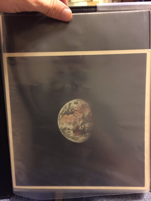
And finally, my personal favorite image of the curvature of the Earth (because I own this original print from 1969):
And closer up, cropped, & out of the sleeve
And finally a high-resolution scan of negative AS11-36-5355 -- whereas mine has faded, has spots on the print, isn't color balanced, and was shot with an iPhone under yellow lighting. So that's why images vary in their final rendering. There is no "true color", there is "what your eye sees under X, Y, and Z conditions".


No comments:
Post a Comment
Note: Only a member of this blog may post a comment.